


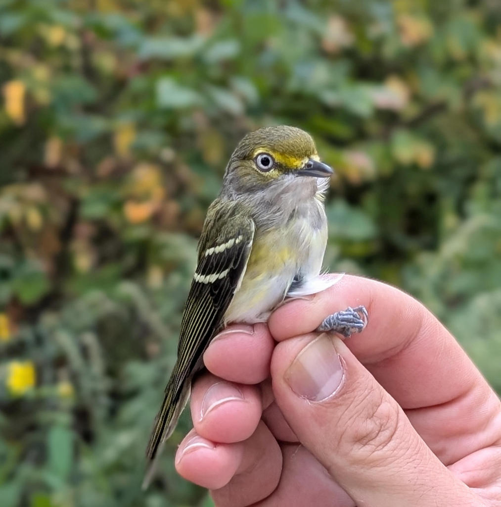
Some birds banded by Bird Lab at Hays Woods: 16 September 2025


Scenes From Hays Woods: July 2025
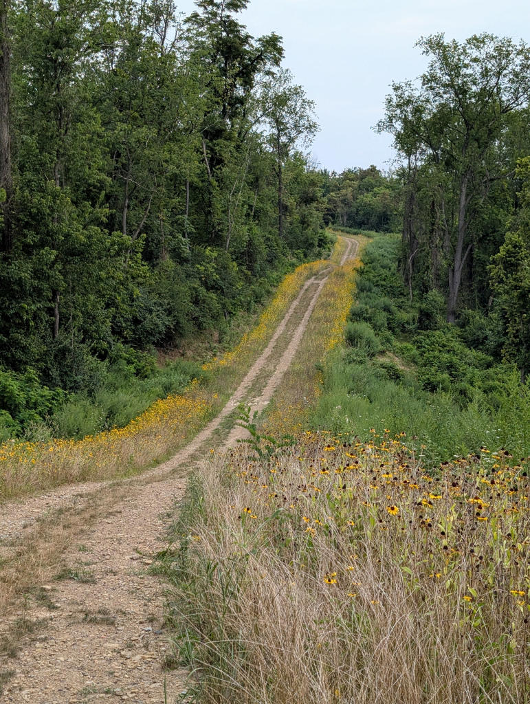
Two years after Duquesne Light built a dirt road to their power towers (see August-October 2023 below), the road is lined with wildflowers in July 2025. Caterpillars make interesting holes in some of the flowers. Butterflies sit the nectar.


WTAE piece on Hays Woods for Earth Month 2024 (click on the image below)

History of the Hays Community and the adjacent Hays Woods by @Noles.Explores
Duquesne Light Gets a New Easement, Builds a Dirt Road Through Hays Woods to Reach Power Towers at Cliff Edge, August-October 2023
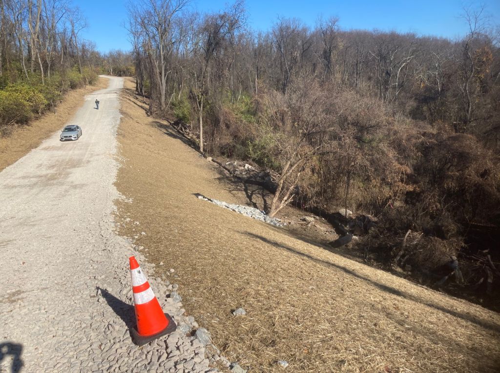
In 2023 Duquesne Light was granted a temporary easement (made permanent in November 2023) to build a dirt road through Hays Woods to reach their transmission lines at the cliff edge above the Monongahela River. The cliff is eroding, threatening their existing power towers. Duquesne Light plans to erect new towers and move the transmission lines. Their contractors began bulldozing in late August 2023. As of November 2023, the completed dirt road is two dump trucks wide and has valley-filled a stream.
This drone video was filmed in September.
Hays Woods Becomes a Public Park, 2021-Present
In November 2021, Pittsburgh City Council authorized the city to buy Hays Woods from the URA for $1, plus costs. Possession of the 624-acre site was transferred to the City.
In July 2023 City Council officially designated Hays Woods as a Pittsburgh city park.
Hays Woods Task Force makes recommendations for the site, 2018-2019
Pittsburgh’s Department of City Planning convened the Hays Woods Task Force to make recommendations for the future of the Hays Woods as a precursor to the master planning process. Click on the links below to read the Final Report
- Hays Woods Task Force Recommendations, August 2019.
- Hays Woods Task Force Appendix A (includes the Vision statement)
The Task Force developed this vision statement for the site:
Hays Woods will be Pittsburgh’s largest and least developed* park, providing quiet space and educational opportunities, habitat for wildlife, climate and ecological benefits to Pittsburgh, and connectivity to local green spaces.
We recommend that the entire Hays Woods site becomes a park and we envision it not only as a park but as a living laboratory for urban forest conservation and climate resiliency. Hays Woods will be an innovative experiential environment where scientists, policy makers, and citizens can design, explore, experience and refine new policies and best practices, and evaluate potential impacts before they are implemented.
Successful techniques developed at Hays Woods will have an impact far beyond the park and will position Pittsburgh as an innovator in urban forest management and climate resiliency.
— Hays Woods Task Force Recommendations, August 2019
Hays Woods Property owned by URA waiting to transfer to City, 2016-early 2021
In June 2016, Pittsburgh’s Urban Redevelopment Authority (URA) purchased Hays Woods land and mineral rights from Pittsburgh Development Group II for $5 million with the intention that it would become the city’s largest urban park.

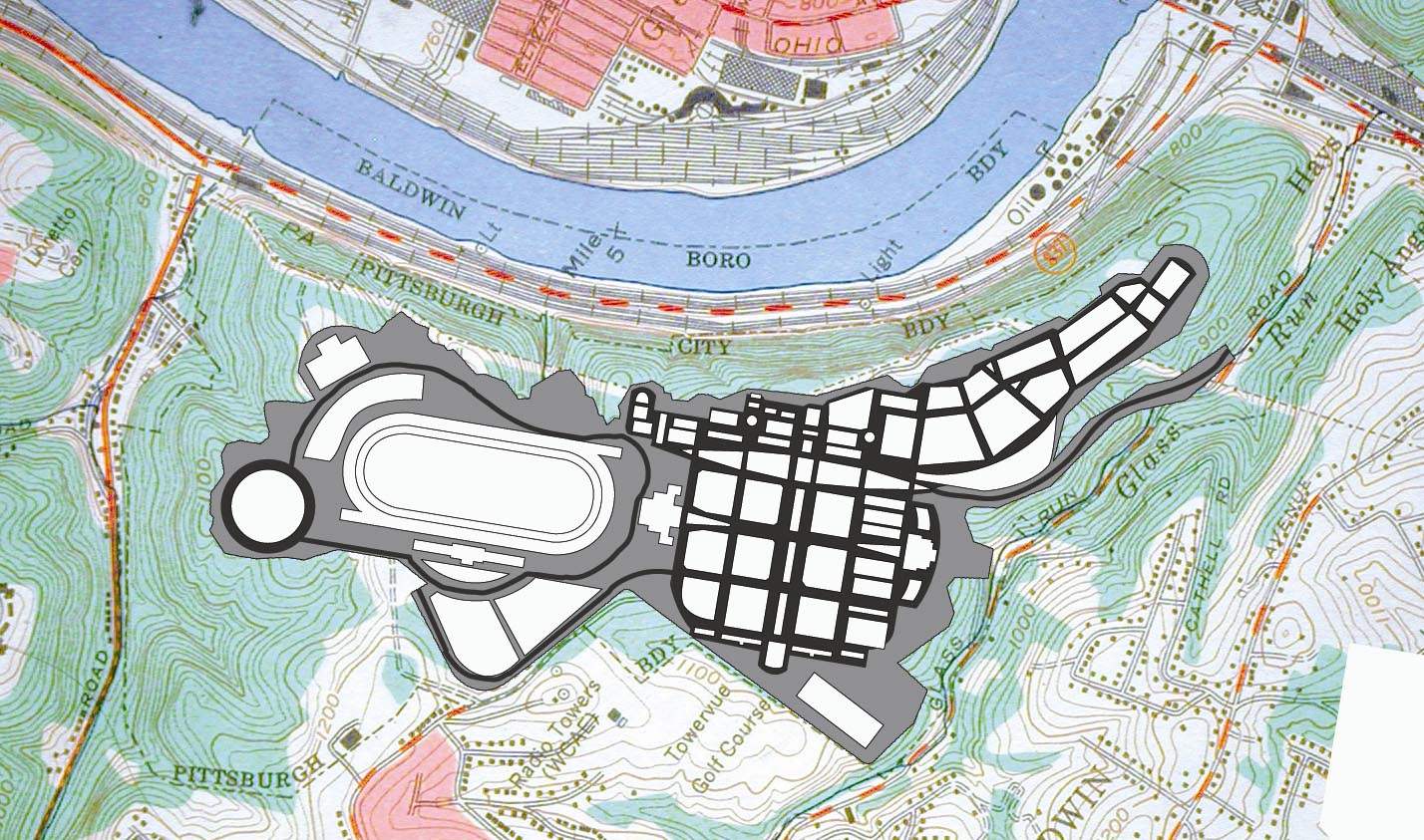
Following through on that plan, the URA Board voted in November 2017 to sell the majority of the land to the city of Pittsburgh for $1 (title transfer pending). However, they withheld 89 acres at the north end of the site for a possible residential development (blue outline in the map below).
In December of 2017, The Department of Conservation and Natural Resources (DCNR) awarded a $800,000 grant to URA to help defray costs of the site’s purchase. In early 2018, Richard King Mellon Foundation gave $2 million to Western Pennsylvania Conservancy (WPC) on behalf of Hays Woods; WPC gave that amount to the URA.
In April of 2018, Pittsburgh Mayor Peduto ordered the formation of a task force to consider the design of Pittsburgh’s future Hays Woods park. The 21 member group is composed of members of the community, environmental advocates and foundation representatives. Task Force committees considered the Hays Woods environment, trail development, programming and education. The DRAFT Hays Woods Task Force Report, April 2019, is available at the Department of City Planning website. The overview is here; Draft Report and Appendix A are on DCP Documents and Maps page.
During Hays Woods Task Force visioning for the site in 2019 it became clear that there was no longer a carve-out for a possible residential development (blue line above). The entire site will be the park.
Racetrack Proposal, 2003-2009
Proposed Palisades Project
Prior to the URA’s purchase, Hays Woods was owned by Pittsburgh Development Group II (PDG), who bought the land in 2003 for $1 million to develop Pittsburgh Palisades Park. Anticipated build-out was to last 20 to 30 years and include a thoroughbred racetrack, casino, commercial area and residential homes.
Preparing the site for development would have involved deforestation and coal mining using mountain top removal (MTR) mining methods. To level the site, the forest’s hills would have been excavated to depths of up to 200 feet and the overburden used to fill in stream valleys and wetlands. The overall elevation of the site would have been reduced by 90 feet.
The Palisades Project was challenged by local environmental groups, the Department of Environmental Protection, the U. S. Army Corps of Engineers, the Pennsylvania Game Commission and other agencies. The project’s mining and gaming permits were denied. In 2009, PDG’s appeal was also denied and the project halted.
Industrial Past, 1930’s-1988

Hays Woods 9/25/1938
Jones and Laughlin Steel Corporation (J&L) purchased Hays Woods and consolidated ownership of the farms and coal and gas mines in the 1930’s. A research laboratory was established on a small portion of the site. In 1974, Long-Temco-Vought Corporation( LTV) acquired J&L and the laboratory was closed. The laboratory and it’s grounds were sold, and the site is now a private academy. Although overhead power lines and underground gas pipelines cross the property, Hays Woods remained unused by industry for many decades. In 1988 LTV Steel sold Hays Woods in bankruptcy court to DGD Realty for $2.71 million.
Forest and Farms, First Settlers to 1930’s
The Pittsburgh neighborhood of Hays, of which Hays Woods is a part, was named for members of the large and successful Hays family who first came to Allegheny County in 1767 and settled in the Homestead and Streets Run areas. The village of Hays grew at the mouth of Streets Run where Six Mile Ferry crossed the Monongahela to connect to Glenwood.
One of the earliest recorded uses of the Hays Woods itself was a farm established on the wooded plateau by Samuel Hays. Later, his daughter married into the Glass family, and the Glass Farm shared the highland above the Monongahela River.
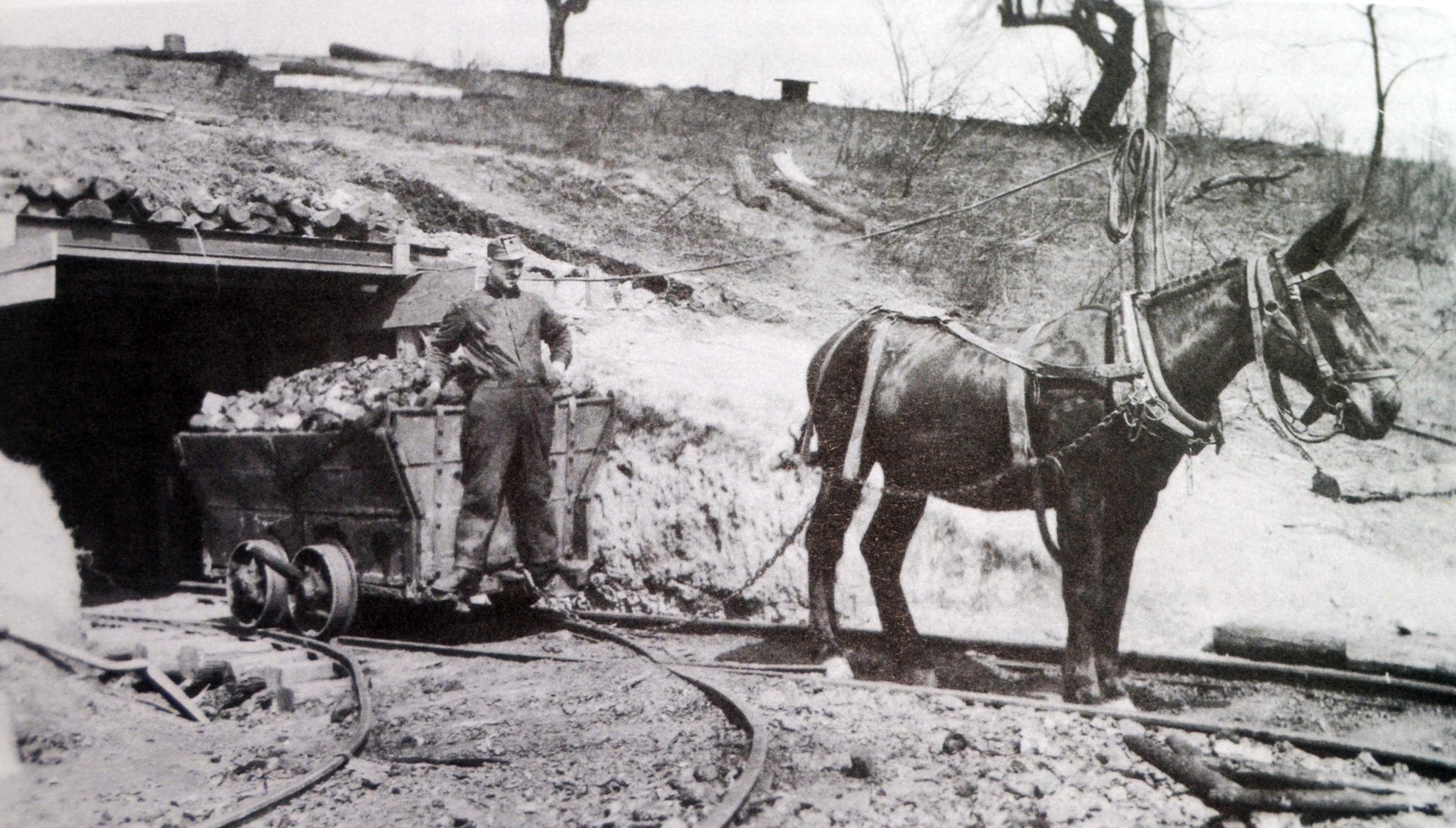
James H. Hays, a grandson of the original settler Abraham Hays, ran drift and deep shaft coal mines in the area. His first mine opened in 1828 near the mouth of Streets Run. Coal was also mined from outcrops on Hays Woods hillsides.
Earliest Inhabitants

Western Pennsylvania’s first modern inhabitants were members of the Shawnee and Lenape Indian tribes. Arrowheads and tomahawks from these nations have been found in the Baldwin area. Eventually these tribes, which were friendly to white settlers, were overcome by the Iroquois Nation around the time of the French and Indian War (1754 until 1758). In the 1700s, French and English fur traders were active in the area. From 1700 to 1800, most of the colonial settlers were farmers. They traded produce and livestock and supplemented their food supply with the region’s plentiful game and fish.
